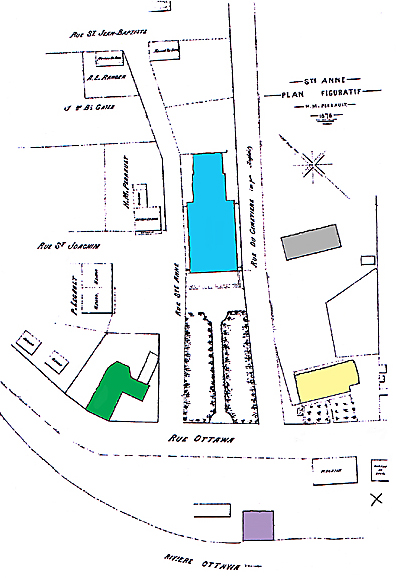
Cette carte montre à quoi ressemblait les environs de l'église de Sainte Anne en 1878. En ce temps, l'ancienne église (environs 1714 - 1900) était toujours debout; elle était utilisée comme école. À côté de la nouvelle église, construite en 1857, était située la route du Cimetière; elle menait au second cimetière. Le premier était situé près de l'eau où est le X dans le coin droit. Les ruines du moulin pouvaient encore être vu. Le presbytère était situé plus près de la rue principale. Un nouveau fut bâti plus tard à côté de l'église utilisée présentement. Le secteur entre la rue et la rivière a changé dramatiquement en 1893. Deux écluses furent construites pour permettre les bateaux de surpasser les rapides de St-Anne.
Ste-Anne-de-Bellevue
- La première église The 1st church
- Église d'aujourdhui The present day church
- Une grange en 1878, maintenant
l'emplacement du presbytère A barn in 1878
now the site of the presbytery
- site de l'ancien moulin Site of the old mill
- Le premier presbytère The earlier presbytery
The map on the left shows what the area around the church of Ste Anne looked like in 1878. At that time, the earlier church (ca 1714 - 1900) was still standing; it was being used as a school. Beside the new church built in 1857 was the cemetery road; it went up to the 2nd cemetery. The first one had been located near the water, about where the X is on the bottom right corner. The ruins of the old mill were still to be seen. The presbytery was closer to the main road. A new one was later built beside the present day church. The area between the street and the river had changed dramatically by 1893; two sets of locks were built so that boats could bypass the Ste Anne Rapids.